The new SR-520 will serve as a barrier to people trying to walk and bike from the Montlake area and neighborhoods further south to the University of Washington and the new University Link station. As currently designed, the project will essentially destroy the walkshed and bikeshed south of the Montlake Bridge.
Over the summer, WSDOT has (in good faith) attempted to make tweaks to the plans to better incorporate walking and biking, but the plans still fall short of acceptable levels of service. Simply put, the new SR-520 will make things worse.
The solution: WSDOT and SDOT must work together to refine the plans (which are still actually in a fairly conceptual stage) before the legislature funds a multi-billion dollar budget that fails to connect people who walk and bike to places they need to be such as the UW, transit stations, schools, parks, workplaces, and other parts of the City.
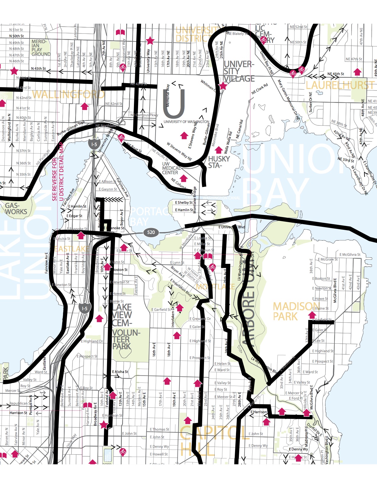
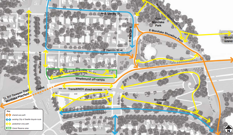
The map below illustrates where Neighborhood Greenway groups forsee family-friendly biking and walking corridors in the near future. It is worth noting that, with the exception of the trans Lake Washington trail, the WSDOT project area currently acts as a barrier to interconnecting this system, and thereby preventing folks from getting to the UW and the University Link. If done properly, the project could operate as a world class hub interconnecting all users to where they need to go! Let’s look as these failings in further detail.
Montlake Bridge Gap

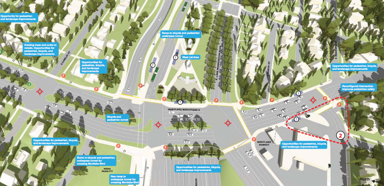
Starting directly south of the new Link Station and UW campus, the Montlake Bridge and car dominated streets create unacceptable levels of service for people who want to walk and bike through the corridor. Furthermore, this is the one of the most heavily used corridors in the City for walking and biking. Unfortunately, the current WSDOT plans do nothing to solve this problem.
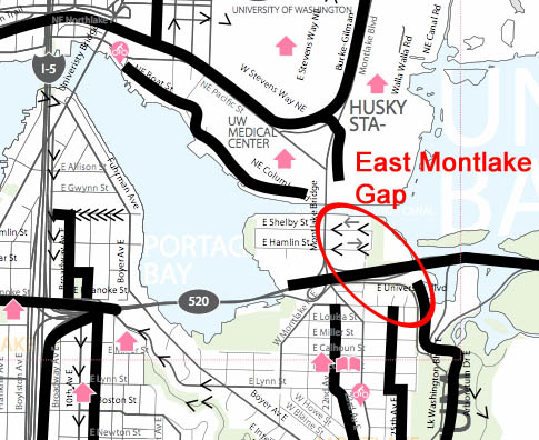
East Montlake Gap
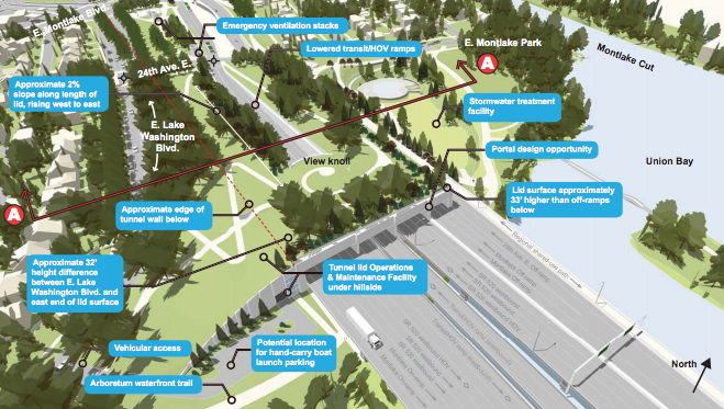
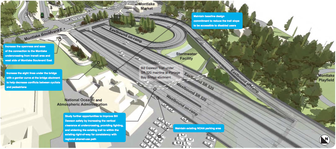
As you can begin to make out in figure 2 below, if you are traveling from the eastern side of Montlake or from Madison Park, WSDOT currently routes you underneath 13 lanes of traffic on the “Arboretum Waterfront Trail.” With thousands of cars per day rushing only a few feet overhead, the noise will be deafening. Furthermore, while WSDOT has promised artificial lighting, this will be a dark and scary place. This will simply create an unacceptable level of perceived and real safety for people walking and biking. This is especially true for the 60% of people who would like to bike, but are intimated by current conditions. For the same amount of money, we can build family-friendly connections that benefit people of all ages and abilities.
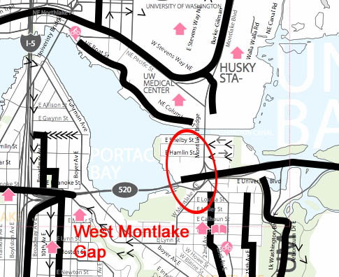
West Montlake Gap
Portage Bay Gap
Final Thoughts
It’s not as if these problems are simply insurmountable technical challenges. WSDOT has the tools and knowledge to complete these missing gaps in a family-friendly way. It simply has not been a priority in designing this massive new project.
It is imperative we get this right. This project area could act as a hub for all forms of transportation, but currently it fails to connect pedestrians and bicyclists to their destinations and to transit. Rather than allowing the new SR-520 to be a barrier to people trying to get to the University of Washington and University Link, we should seize this once is a lifetime opportunity to better connect our neighborhoods, our city, and our region.
FAQ: Many astute readers have asked great questions. Here is a collection of some quick responses:
Why Not 24th Ave E?
What about the paths on the lids?
Why no specific engineering solutions?
Although a number of engineers are part of Central Seattle Greenways, WSDOT and SDOT have their own team of engineers willing and eager to solve these problems if asked to do so. We have been told that the best way to be effective is to articulate the problems for walking and biking and to work with the City and WSDOT to give them the ability to work on potential solutions.
Are you attempting to be adversarial?
Also, WSDOT deserves some serious credit for their design of the Roanoke Lid area. They have done a excellent job incorporating walking and biking facilities into the design!
Why is Central Seattle Greenways advocating for family-friendly infrastructure in Montlake?
Central Seattle Greenways has in effect become the spokes-group for the three Seattle Neighborhood Greenway groups that are most involved in this project: Montlake Greenways, Madison Park Greenways, and Central Seattle Greenways. Furthermore, people living on east Capitol Hill heading north, or people heading north via the Portage Bay Bridge Trail, need to be able to move through this area easily and comfortably. No neighborhood exists in isolation – we need a system of low-stress family-friendly bicycle and pedestrian infrastructure that knits our neighborhoods, our City, and our region together.


 RSS - Posts
Pingback: Bike News Roundup: Sh’Bang! ByCycle | Seattle Bike Blog
Pingback: SR-520 Design will discourage walking and biking to the UW and University Link | From Cascadia With Love
Pingback: A Year of Action: CSG is One Year Old! | Central Seattle Greenways
Pingback: Let’s Create a Great 23rd Ave Corridor Greenway | Central Seattle Greenways